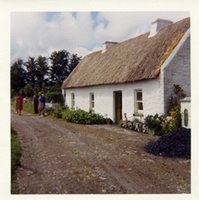
 Among the items in the Dowd Collection was this photo of a thatched roofed home located somewhere in the county of Roscommon, Ireland. In 1966 the Dowd family visited Ireland and located the McDonough homestead. Along with this picture were others on 35mm slides. The slides are a series of images of the house, the surrounding views of the countryside from the farm, and images taken along the road leading to or from the farm.
Unfortunately, while scanning the slides I experienced some technical difficulties. I have other images of the home and farmstead to share in future posts, but one image in particular I am missing - a photo of a sign post which must be near the old McDonough farm. While I am missing the image, I do have the information on the sign.
Pointing left to Geevagh 5 1/2 and Drumshanbo 17 and right to Ballygawley 4 and Sligo 10

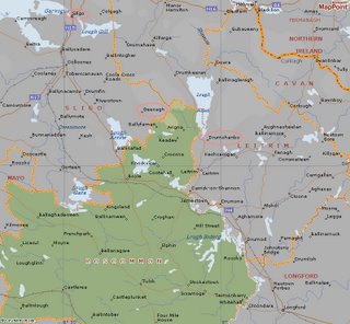
If you click on the map above to view larger, you will see that I have found and circled three of the four locations from the sign. It appears that the most likely area of Roscommon that the farm is located is in the Northern area and near the Sligo boarder.
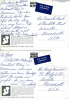
 The Roscommon riddle that we need to solve is this - given the information in the postcards, the picture, information from the sign, and locations on the map - can we narrow down a specific location for the farm?
As always any additional information or suggestions are welcome either by email or in the comments.
Labels: Dowd_Collection, McDonough


It appears that the sign post may have been located in the town of Ballinakill, County Sligo, Ireland on the Irish regional road R284.
Since the road crosses from Sligo into Roscommon, I have to assume the photo of the sign post was taken on route to the farm. The post cards clearly say the farm is in Roscommon.
Exact location of the farm is still a mystery, but at least now we know it is near the R284.
I know precisely where that farm was--it was my grandfather's, Pat McDonough, and the site is now the summer home of a cousin who lives in CT. I have the precise photo shown on your site, and my mother, Winifred McDonough Quinn, was there the day it was taken. I have anotehr from perhaps moment sbefore showing the various persons in that photo, as well. Would love to see your other photos. Email me at tquinn@unum.com, tquinn1@maine.rr.com, or call 207-774-4419.